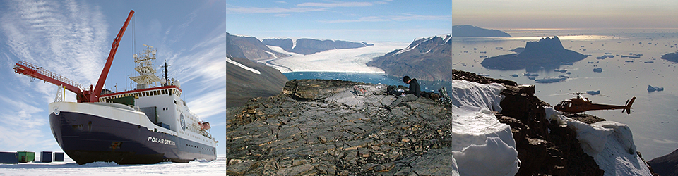
Cruise PS100
NEGIS: Understanding the Mechanisms Controlling the Long-Term Stability of the Northeast Greenland Ice Stream
D.H. Roberts (DUR); J.M. Lloyd (DUR); C. Ó Cofaigh (DUR); S.L. Callard (DUR); H. Grob (AWI); M. Kappelsberger (AWI)
Grant-No. AWI_PSXX_0X
4.1 Background
The NEGIS project is supported through the Alfred Wegener Institute (Project N405) via the GRIFF I project and the Polarstern programme (Cruise PS100) as well as through the UK Natural Environment Research Council (NERC Grant NE/N011228/1). The incursion of warm Atlantic Water (AW) over the last 15 years to many Greenland marine-terminating glaciers, as well as increased air temperatures and sea-ice loss, have all been linked to ice margin retreat and instability (Straneo et al., 2012; Mouginot et al., 2015; Wilson et al., 2015). However, despite our improved understanding of the forcing mechanisms that have driven recent glacier change in Greenland, the limited time-span of our observations provide only a short time series with which to understand the complex and non-linear response of ice streams to ocean and atmospheric forcing (Nick et al., 2010). This hinders our ability to understand and forecast how ice sheets will change over longer timescales (Seroussi et al., 2014). What we fundamentally lack is decadal to millennial scale input data with which to calibrate, validate and test the sensitivity of predictive models. One solution to this issue is to identify patterns of former rapid ice margin change during periods of warmer climate when the key forcing mechanisms that influence ice sheet stability can be simultaneously reconstructed so their relative importance can be determined.
This project will investigate the dynamics of the Northeast Greenland Ice Stream (NEGIS); the main artery for ice discharge from the NE sector of the Greenland Ice Sheet (GrIS) to the North Atlantic. Unlike other sectors of the GrIS, NEGIS and the ice shelves that front it, have exhibited little response to increased atmospheric and oceanic warming over the last 20 yrs. However, very recent ice shelf loss and grounding line retreat (~ 4 km) post 2010 suggest that this sector of the GrIS, and NEGIS in particular, is starting to respond to recent atmospheric/oceanic change (Mouginot et al., 2015). Model projections suggest that ocean warming will double by 2100 (Yin et al., 2011) and air temperature will increase significantly in northeast Greenland (AMAP, 2011), so the future evolution of the NEGIS catchment is important not only for understanding changing dynamics in this sector of the GrIS, but also for predicting sea-level rise. The NEGIS catchment as a whole holds a significant sea-level equivalent (SLE) of 1.1 to 1.4m, but it is the marine-terminating end of the NEGIS system that is particularly vulnerable to marine ice sheet instability because it sits within a series of interconnected, over-deepened, subglacial troughs; those troughs harbour a SLE of 0.12 – 0.35 m. A rapid retreat of this system would therefore have significant consequences for global sea-level rise.
A critical underlying component of this project is previous research that demonstrated that one of the NEGIS ice shelves (known as ‘79N’) retreated 80km during the mid-Holocene Thermal Maximum (HTM; 8.0 – 5.0 ka BP) (Bennike and Weidick, 2001). 79N is the only large-scale ice stream/shelf outlet system in Greenland that has a partially constrained Holocene retreat and re-advance history (Bennike and Weidick, 2001). The HTM was a period when radiative forcing and summer temperatures were up to 2°C higher than present, and analogous to those predicted for the next 100 yrs and beyond. Hence, increased air temperature could have played a role in ice stream fluctuation and ice shelf collapse, but we presently lack the data to assess the role of different forcing mechanisms (e.g. ocean warming) on ice stream fluctuation. This limits our ability to predict the response of NEGIS to future change.
The overall aim of this project is to reconstruct the history of the NEGIS from the end of the last glacial maximum (LGM) and through the Holocene. Working both onshore and offshore the project will generate a series of tie points to reconstruct ice sheet thickness, grounding line position, and ice shelf presence/absence. It will also generate a time series of forcing data on ocean and atmospheric temperatures. These datasets will be used to test and model the sensitivity of the ice stream to different forcing mechanisms at 100 – 1000 yr timescales.
4.2 Objectives
The project has three main objectives:
- Objective 1: To constrain ice stream/ice shelf extent and thickness in order to determine rates of retreat and re-advance between 15 – 0 ka BP.
- Objective 2: To constrain oceanographic and atmospheric conditions and sea-level change adjacent to NEGIS between 15 – 0 ka BP.
- Objective 3: To apply the 3D BISCICLES numerical ice sheet model to test the sensitivity of NEGIS to atmospheric/oceanic /sea-level forcing and to explore feedbacks over 1000 yr timescales.
4.3 Work at sea
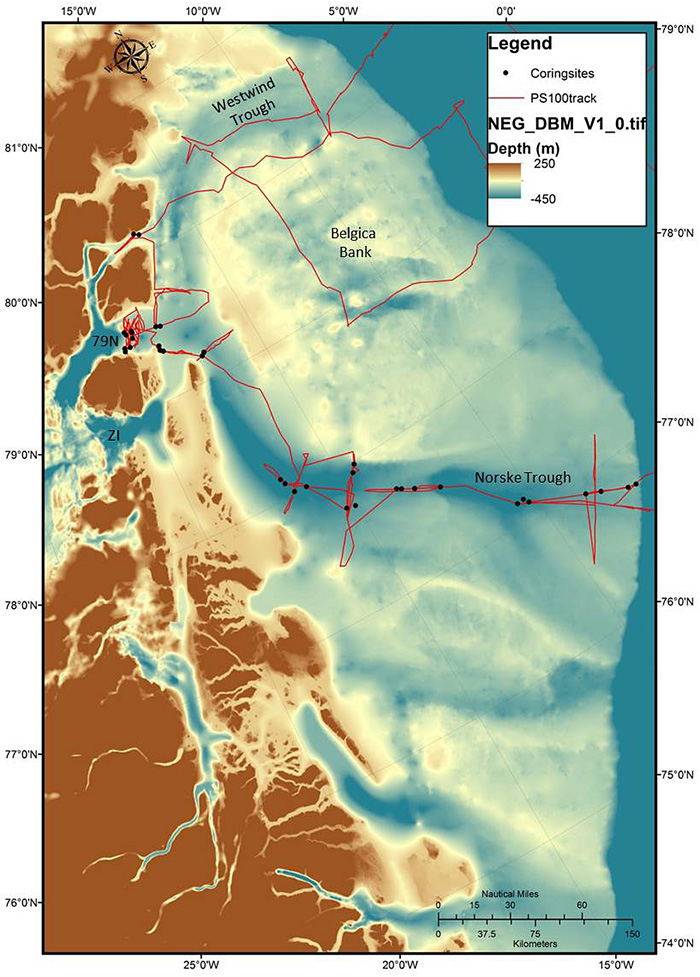
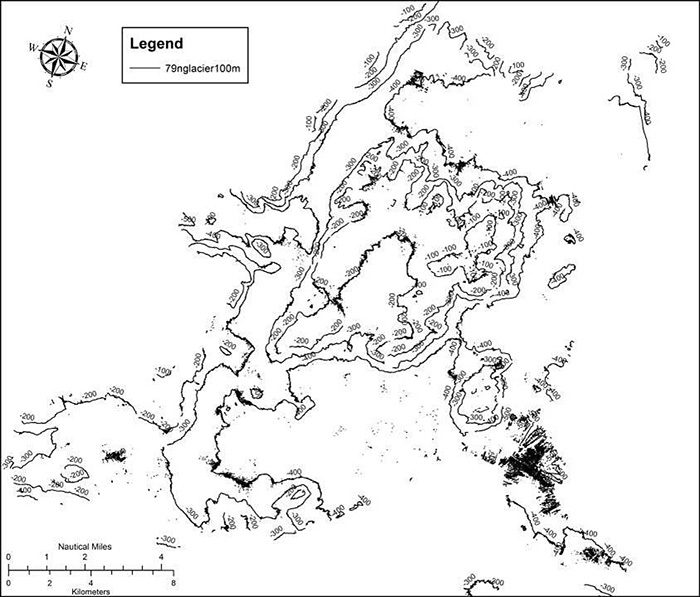
During cruise PS100 the NEGIS project has concentrated on Objectives 1 and 2. We have principally collected data from the Norske Trough and the area in front of the 79N ice shelf. However, bathymetric and sub-bottom profile data were also collected using the Hydrosweep and Parasound systems from areas in the Westwind Trough and across the Belgica Bank (Figure 4.1). The bathymetric data was collected on the hull-mounted ATLAS Hydrosweep DS3 multibeam echo-sounding system. The instrument operated at a frequency between 13.6-16.4 kHz and was calibrated using sound velocity measurements of the water column collected from CTD stations. The data was processed and cleaned in CARIS Hips and Sips. The sub-bottom profiler data was collected using a hull-mounted Parasound DS III-P70 system operating at a pulse mode of between 4-20 kHz and a pulse length of 0.5 ms. The seismic profiles were visualized using PS3 file formats on SeNT v 2.02.
The main aim of using the Hydrosweep system has been to establish the bathymetry and seafloor geomorphology of key areas and to characterise the geomorphological imprint and extent of the ice sheet across the NE Greenland shelf. The Norske Trough has been a key focus because it is thought to have funneled ice offshore during the last glacial cycle and influenced ice flow pathways during ice sheet retreat at the start of the Holocene. The Parasound sub-bottom profiler system has enabled us to acquire sub-seafloor acoustic stratigraphic data. This provides not only an insight into the erosion and deposition of glacial and glaciomarine sediments across the seafloor, but has been critical in guiding the location of coring activity. Our coring strategy has been three-fold; 1) to sample different types of glacial, glaciomarine and marine sedimentary environments to establish ice sheet behaviour.
4.4 Preliminary results
4.4.1 Norske Trough – Seafloor geomorphology and acoustic stratigraphy overview
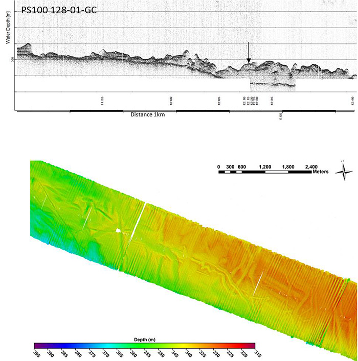
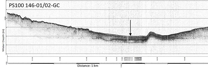
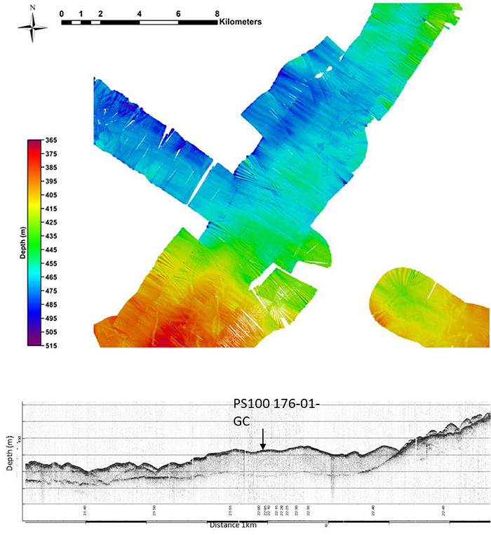
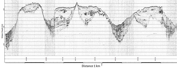
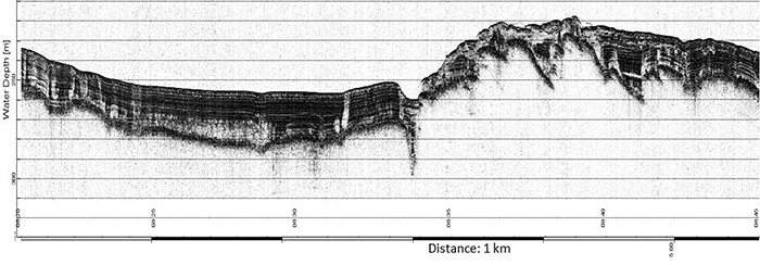
The outer Norske Trough seafloor has several geomorphic and sedimentary features of note. Parasound data was particularly useful in revealing possible till units and grounding zone wedges marking ice advance to the outer shelf and its subsequent retreat (Figure 4.2). In many instances these sediments have been heavily disturbed and dissected by iceberg scour which followed ice retreat to the northwest. Deeper basins over 400 m bsl on the outer shelf also revealed slightly thicker sedimentary records with over 20 m of sedimentary infill and four on-lapping units visible at core site PS100 146-01-GC (Figure 4.3). Such deeper, un-scoured, areas suggest iceberg drafts did not exceed 400m.
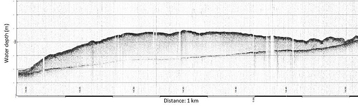
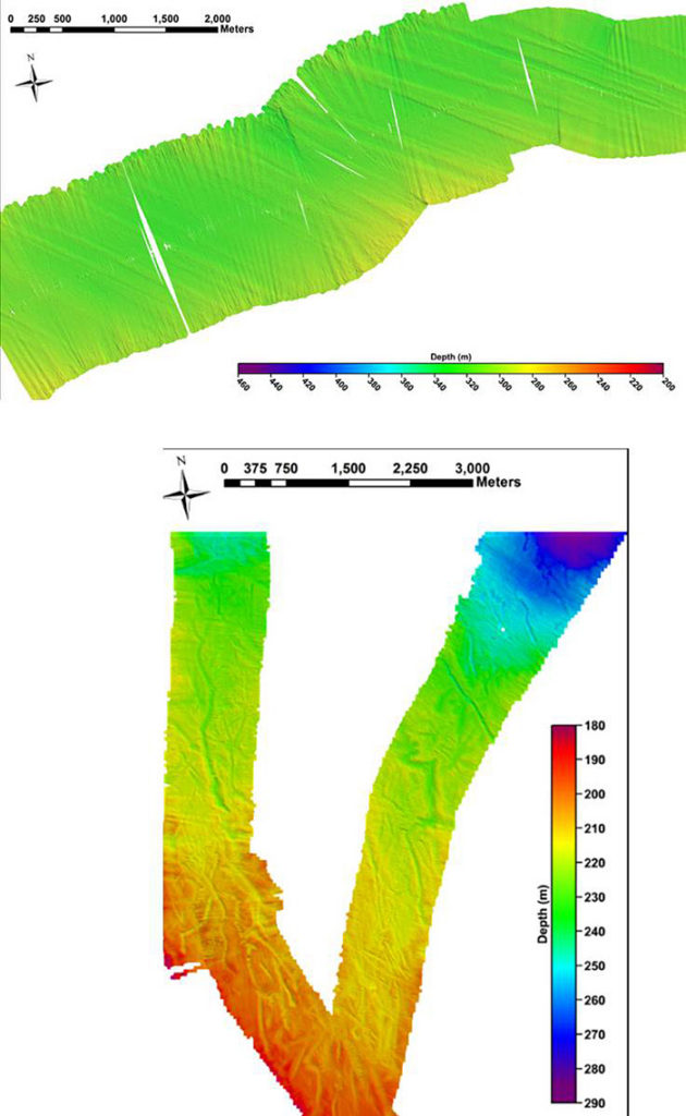
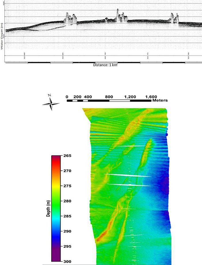
The mid-trough area is characterised by a series of grounding-zone wedges marking ice sheet retreat (Figure 4.4) and in areas the seafloor is clearly streamlined with both drumlins and mega-scale glacial lineations formed across an area that appears to show an upper and lower till (Figure 4.5). In places the streamlined terrain is draped by deglacial marine sediments that also infill some small basins.
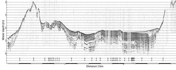
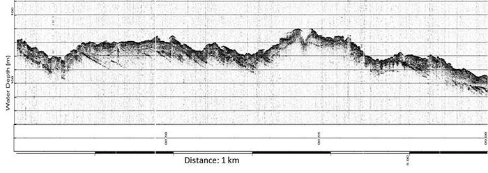
The inner trough and embayment in front of the 79N margin display a marked transition in seafloor morphology and sedimentary environments with distinctive stratified basins separated by ice scoured bedrock highs in places shallower than 100mbsl (Figure 4.6). In areas the sedimentary infills are over 75 m in thickness. They consist of stratified clays that most probably represent deglacial and Holocene glaciomarine sedimentation. Several cores from these basins are characterised by laminated/colour banded red and grey clays. Overlying the stratified sediments are acoustically massive sediments which most likely represent debris flow activity fed from adjacent slopes, as well as sub-ice shelf sedimentation beneath areas formally covered by the ice shelf (Figure 4.7). In areas east of the present ice shelf, the bedrock highs form classic knoc’n’lochan topography across the seafloor pointing to intensive subglacial abrasion and plucking prior to marine inundation (Figure 4.8).
4.4.2 Westwind Trough – Seafloor geomorphology and acoustic stratigraphy overview
The Westwind Trough runs NE to E away from the coast towards the shelf break. It is generally shallower than the Norske Trough being less than 350m deep for most of its length. The seafloor geomorphology of this trough shares some similar characteristics to Norske Trough with streamlined bedforms (e.g. mega-scale lineations/drumlins) and iceberg scours being particularly prevalent (Figure 4.9). Grounding-zone wedges are not as common, but moraines are clearly identifiable and have been previously reported by Winklemann et al. (2010) (Figure 4.10). The glacial sediment cover on the outer- and mid-shelf is relatively thin (often less than 5m) and in many areas dipping bedrock strata can be clearly seen close to the seabed (Figure 4.11). Only on the inner trough close to Dimphna Sund does the glacial sediment thickness increase with deep, deglacial sedimentary infills similar to those observed in the inner parts of the Norske Trough and close to the 79N glacier (Figure 4.12).
4.4.3 Sedimentary Environments
Based on the Parasound data a number of acoustic facies (AF) were identified and several core locations were deliberately chosen to establish the nature of these facies and the type of glacial and glaciomarine sediments below the seafloor.
Subglacial Tills (AF 1 + AF 2)
In several areas in the outer- and mid-Norske Trough the lowest acoustic reflector in the sequence (AF1) was accessible at the seabed. Cores PS100 126-01 and 174-01 sampled this reflector and recovered a grey/brown, stiff, massive diamict with shear strength over 100 kPa. This is typical of a subglacial till. In other areas in the mid Norske Trough area a second acoustic facies (AF2) above the lower till (AF1) formed a stratigraphic unit up to 15 m thick that was clearly streamlined (Figure 4.5). This unit was sampled in core PS100 175-01-GC and was composed of dark, massive grey clay with low shear strength (~20kPa).
Glaciomarine stratified infills (AF3)
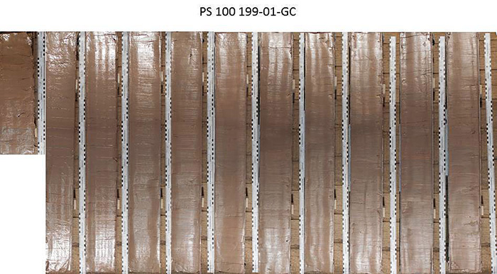
Across much of the outer- and mid-Norske Trough deglacial stratified sediments and drapes are difficult to map due to intense iceberg scour. However, on the inner shelf, deep basins below 400 m preserve well stratified sediments in depo-centres that escaped intensive scour during deglaciation and the Early Holocene. These sediments were sampled in several cores (e.g. PS100 198-01; 199-01; 207-01; 208-01; 248-01; 249-01) and contained laminated clays which often display alternating (occasionally rhythmic) red and grey colour bands, though there is no obvious change in grain size (Figure 4.13). These sediments are interpreted as glaciomarine in origin and could relate to variations in source from the 79N and Zachariae Isstrom catchments or be related to variations in seasonal oceanic and sea-ice conditions. Further analysis will follow.
Debris Flows (AF4)
In many locations deeper basins are on-lapped from steep marginal areas by debris flows. These are clearly distinguishable in the Parasound data as wedges and lobes that are slope conformable, usually acoustically transparent or homogeneous and overlap older basin stratified sediments (Figure 4.8). In core PS100-177-01-GC the upper part of a debris flow unit was composed of soft brown/grey, massive clay with dispersed pebbles and cobbles with low shear strength (2-4 kPa).
Sub-shelf facies (AF 5 and AF 6)
In several localities close to the present 79N ice shelf edge both transparent and opaque sedimentary facies conformably drape lower stratified basins. Where sampled they are composed of very soft, massive, red clays. These may represent sub-ice shelf facies but further analysis is required.
4.4.4 Foraminiferal analysis
Selected samples were chosen for qualitative foraminiferal analysis – principally from surface samples collected from box core sites, but also some subsurface samples. For each sample analysed, approximately 10 ml of sediment was added to a glass beaker with water and left to disaggregate for approximately 1 hour. Samples were then washed through a 500 µm and 63 µm mesh sieve. The residue coarser than 63 µm was collected and examined using a Leica binocular microscope. Samples were examined wet to reduce potential loss of fragile agglutinated specimens.
Samples were selected from a range of sites covering the coring transect from the outer part of the Norske Trough through the mid- and inner-trough to the embayment immediately in front of the modern ice shelf. All samples contained benthic foraminifera, often in high abundances. There was a mixture of agglutinated and calcareous species and also many samples contained planktic specimens (Neogloboquadrina pachyderma). A basic description of the faunas found will be presented below along with a brief environmental interpretation starting with the cores in the outer section of Norske Trough.
Core PS100-129-01-GC
This core was collected from outer Norske Trough. A surface sample investigated contained an abundant agglutinated fauna dominated by Adercotryma glomerata, Saccammina diflugiformis, Saccammina subfusiformis, and Trochammina nana. There were also some calcareous species present in low abundances (e.g. Cassidulina neoteretis, Elphidium albiumbilicatum). The planktic foraminifera, Neogloboquadrina pachyderma, was also present. The agglutinated fauna present is indicative of an Atlantic Water influence at the sea floor (relatively warm and saline conditions).
Core PS100-127-01-GC
This core was also collected from the outer section of the Norske Trough. A sample towards the base of the gravity core collected at this site was investigated (170 cm). The fauna was dominated by calcareous species with the following species particularly abundant: Cassidulina neoteretis, Cassidulina reniforme, Cibicides lobatulus, Elphidium excavatum forma clavata and Melonis barleeanum. The planktic foraminifera, Neogloboquadrina pachyderma, was also abundant in this sample. The benthic fauna present in this sample is rather mixed; the presence of C. neoteretis suggests the presence of Transformed or Chilled Atlantic Water at this time, while the presence of E. excavatum f. clavata and C. reniforme in particular are indicative of colder Arctic Water.
Core PS100-171-01-BC
This core was collected from the mid-trough and a surface sample from the box core was investigated. The sample is characterised by an abundant and diverse assemblage, with particularly abundant planktic foraminifera (N. pachyderma). The benthic foraminiferal assemblage is dominated by calcareous species, but with some agglutinated species also present. Common species include C. neoteretis, Islandiella hellenae, M. barleeanum and E. albiumbilicatum. The fauna suggests the influence of the Atlantic Water on bottom waters in this region.
Core PS100-249-01-BC
This core was collected from the embayment in front of the present day margin of the ice shelf of 79N glacier. The surface sample investigated from the box core recovered a rich and diverse benthic foraminiferal assemblage dominated by calcareous species, but with some agglutinated species also present. Common species include: C. reniforme, C. neoteretis, E. excavatum, I. hellenae and Quinqueloculina spp. This fauna is slightly more mixed with evidence of Atlantic Water influence (C. neoterestis) but also evidence of colder Arctic Water (C. reniforme and E. excavatum).
4.5 Data management
A number of cores were split during cruise PS100, logged and described sedimentologically, but most cores remain unsplit. Samples were also taken from the cores for foraminiferal analysis. The cores will be shipped to Durham University for multi-sensor core logger (MSCL) measurements (e.g. bulk density, porosity, grainsize, P-wave velocities and water content), XRF and XCT 3D X-ray analysis. Foraminiferal, stable isotope analyses and sediment geochemistry (TOC, TN, C/N analysis) will also be conducted at Durham. The cores will be archived at AWI post analysis. Sample processing for radiocarbon dates (14C) will be carried out at the NERC radiocarbon Laboratory, UK. All data will be uploaded to the PANGAEA database. Unrestricted access to the data will be granted after about three years from the end of the cruise, pending analysis and publication.
| SAMPLE NAME | EQUIPMENT | LATITUDE (N) | LONGITUDE (W) | WATER DEPTH (M) | CORE RECOVERY (CM) |
| PS100 126-01 GC | Gravity corer | 76 44.637 | 7 13.250 | 312 | 22 |
| PS100 127-01 GC | Gravity corer | 76 45.549 | 7 28.353 | 312 | 183 |
| PS100 128-01 GC | Gravity corer | 76 51.081 | 8 13.080 | 344 | 141 |
| PS100 129-01 GC | Gravity corer | 76 54.15 | 8 38.64 | 362 | 286 |
| PS100 143-01 GC | Gravity corer | 77 5.309 | 10 14.304 | 449 | 197 |
| PS100 144-01 GC | Gravity corer | 77 7.495 | 10 34.239 | 496 | 217 |
| PS100 144-02 BC | Giant box core | 77 7.583 | 10.34.186 | 494 | 43 |
| PS100 146-01 GC | Gravity corer | 77 31.366 | 12 20.166 | 505 | 376 |
| PS100 146-02 GC | Gravity corer | 77 31.381 | 12 20.131 | 505 | 586 |
| PS100 147-01 GC | Gravity corer | 77 36.724 | 13 4.674 | 379 | 246 |
| PS100 148-01 GC | Gravity corer | 77 39.519 | 13 27.095 | 380 | 19 |
| PS100 148-02 GC | Gravity corer | 77 39.505 | 13 27.118 | 381 | 348 |
| PS100 149-01 GC | Gravity corer | 77 40.641 | 13 35.439 | 369 | 45 |
| PS100 171-01-BC | Giant box core | 78 8.449 | 16 50.139 | 542 | 51 |
| PS100 171-02-GC | Gravity corer | 78 8.482 | 16 49. 739 | 545 | 410 |
| PS100 172-01-GC | Gravity corer | 78 5.980 | 16 45.618 | 522 | 393 |
| PS100 173-01-GC | Gravity corer | 78 0.556 | 16 10.236 | 505 | 366 |
| PS100 174-01-GC | Gravity corer | 77 43.350 | 15 2.613 | 376 | 150 |
| PS100 175-01-GC | Gravity corer | 77 44.264 | 15 20.141 | 375 | 158 |
| PS100 176-01-GC | Gravity corer | 77 56.017 | 14 34.048 | 443 | 392 |
| PS100 177-01-GC | Gravity corer | 77 58.890 | 14 23.252 | 400 | 200 |
| PS100 184-01-GC | Gravity corer | 78 1.162 | 16 36.213 | 493 | 201 |
| PS100 185-01-GC | Gravity corer | 48 5.542 | 16 11.980 | 480 | 410 |
| PS100 198-01-BC | Giant box core | 79 11.333 | 17 6.950 | 393 | 44 |
| PS100 198-02-GC | Gravity corer | 79 11.474 | 17 6.430 | 398 | 960 |
| PS100 199-01-GC | Gravity corer | 79 10.390 | 17 14.023 | 400 | 1061 |
| PS100 207-01-GC | Gravity corer | 79 19.767 | 18 27.879 | 269 | 932 |
| PS100 208-01-GC | Gravity corer | 79 20.613 | 18 33.202 | 304 | 935 |
| PS100 209-01-GC | Gravity corer | 79 20.754 | 18 33.727 | 311 | 487 |
| PS100 210-01-GC | Gravity corer | 79 22.562 | 18 31.414 | 193 | 373 |
| PS100 242-01-GC | Gravity corer | 79 27.325 | 19 32.883 | 293 | 500 |
| PS100 243-01-GC | Gravity corer | 79 27.810 | 19 45.653 | 124 | 0 |
| PS100 244-01-GC | Gravity corer | 79 26.520 | 19 47.559 | 327 | 892 |
| PS100 245-01-GC | Gravity corer | 79 32.811 | 19 28.880 | 143 | 116 |
| PS100 246-01-GC | Gravity corer | 79 34.117 | 19 30.270 | 472 | 842 |
| PS100 247-01-GC | Gravity corer | 79 32.7 | 19 14.224 | 205 | 890 |
| PS100 248-01-GC | Gravity corer | 79 33.400 | 19 13.358 | 170 | 915 |
| PS100 249-01-GC | Gravity corer | 79 30.405 | 19 19.114 | 310 | 1000 |
| PS100 249-02-BC | Gravity corer | 79 30.411 | 19 19.202 | 310 | 0 |
| PS100 269-01-GC | Gravity corer | 79 30.429 | 18 18.108 | 470 | 886 |
| PS100 270-01-GC | Gravity corer | 79 29.824 | 18 8.399 | 424 | 944 |
| PS100 275-01-GC | Gravity corer | 80 9.748 | 17 23.960 | 166 | 782 |
| PS100 276-01-GC | Gravity corer | 80 8.502 | 17 13.049 | 170 | 671 |
4.6 References
- AMAP (2011) Arctic Climate Issues 2011: Changes in Arctic Snow, Water, Ice and Permafrost. SWIPA 2011 Overview Report
- Bennike O, Weidick A (2001) Late Quaternary history around Nioghalvfjerdsfjorden and Jøkelbugten, North-East Greenland. Boreas, 30, 205-227
- Mouginot, J, Rignot E, Scheuchl B, Fenty I, Khazendar A, Morlighem M, Buzzi A, Paden J (2015) Fast retreat of Zachariæ Isstrøm, northeast Greenland. Science, DOI: 10.1126/science.aac7111
- Nick F, van Der Veen CJ, , Vieli A, Benn D (2010). A physically based calving model applied to marine outlet glaciers and implications for the glacier dynamics. Journal of Glaciology, 56, 781-794
- Seroussi H, Morlighem M, Rignot E, Mouginot J, Larour E, Schodlok M, Khazendar A (2014) Sensitivity of the dynamics of Pine Island Glacier,West Antarctica to climate forcing for the next 50 years. The Cryosphere, 8, 1699-1710
- Straneo F, Sutherland D, Holland D, Gladish C, Hamilton GS, Johnson HL, Rignot E, Xu Y, Koppes M (2012) Characteristics of ocean waters reaching Greenland’s glaciers, Ann. Glaciol., 53(60), 202-210
- Wilson NJ, Straneo F (2015) Water exchange between the continental shelf and the cavity beneath Nioghalvfjerdsbræ (79 North Glacier). Geophys. Res. Lett., 42, 7648-7654.
- Winklemann D, Jokat W, Jensen, Schenkeb WK (2010). Submarine end moraines on the continental shelf off NE Greenland – Implications for Lateglacial dynamics. Quaternary Science Reviews, 29, 1069-1077
- Yin J, Overpeck JT, Griffies SM, Hu A, Russell JL, Stouffer RJ (2011) Different magnitudes of projected subsurface ocean warming around Greenland and Antarctica. Nature Geoscience, 4, 524-528